Ionospheric Map

Ionospheric foF2 Map
A feature of the ionosphere is its ability to reflect radio waves. However, only radio waves within a certain frequency range will be reflected and this range varies with a number of factors.
The most widely used instrument for ionospheric measurement is the ionosonde. The ionosonde is essentially a high frequency radar which sends short pulses of radio energy into the ionosphere. If the radio frequency is not too high, the pulses are reflected back to earth.
The ionosonde records the time delay between transmission and reception of the pulses. By varying the frequency of the pulses (typically 1-22 MHz), a record is obtained of the time delay at different frequencies. This record is referred to as an ionogram.
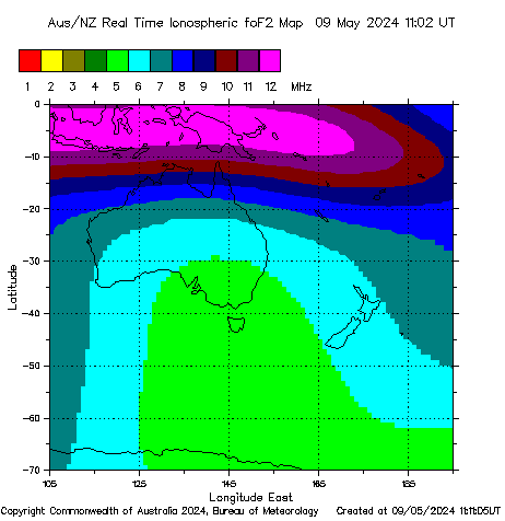
The highest (see note) frequency which the ionosphere will reflect vertically is called foF2. These foF2 measurements from various sites can be used to create a map of foF2.
The above map can be used as a guide to NVIS ionospheric frequency support.
The map is updated every 15-minutes, using Space Weather Network data.
Note: The geomagnetic field splits a radio wave in the ionosphere into two separate components, termed the ordinary (o) and extraordinary (x) waves. It is the o-wave which is routinely scaled from ionograms.


